Object Classification within ArcGIS Pro
Classifying objects and structures can be very helpful. Whether it be vegetative features, buildings, runoff, rivers, etc. all these features can be accessible through Arc in a variety of ways. Today I will be showing a tools that aid greatly in the classification of features.
To begin Esri offers a great step-by-step tutorial on how to use the Classification Wizard, which allows users to create classes of features they want to define, manually outline some of these features, and have the tool automatically define and process the rest.
When using the wizard I created two classes to be defined. Those being impervious and pervious features. Above is a neighborhood downloaded through esri that has been partially manually drawn in as impervious (buildings, pavement, etc.) features and pervious (grass, trees, water, etc.) features. However, so much more can be analyzed using the wizard tool.
Above is a mission I flew a few weeks back. Using the wizard I was able to classify light vegetation, heavy vegetation, roads, and barren/burnt ground. However, so many more features can be defined given the necessity.
Adding on, I just wanted to find the prominent grass I was flying over during the mission. So, with an underlying dsm I added the classified grass atop. Notice that now, when clearing out other selected features, one can easily tell which features appear and where.
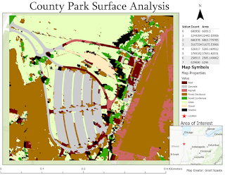
Above is an example of a map with many features being classified all in one. This though somewhat overwhelming, is an example of how detailed the classification process can be.
With resampling and some detailed manual outlying of classification polygons, one can also create a detailed representation. Below is an image of about 20-30 feet of road which has been colored differently than surrounding vegetation. Within the roads we can see orange cracks which have been defined both by hand and using Arc software to fill in the rest.
Furthermore, area has been defined with a tied value number which can be deciphered within the map symbols subsection. All-in-all, object classification has a great many of uses, can be on a massive or small scale, and is only limited by imagination.


Comments
Post a Comment